
Mt Khao Laem - Koh Chang
- Cmac
- Nov 20, 2020
- 4 min read
Updated: Oct 24, 2025
NOTES
Height - Approximately 650m total elevation
Trail length - Approximately 8-10 km
Time required - 1.5-3 hrs for ascent & 1-2 hrs for decent
Rope - There is rope in sections
Difficulty & Danger - Medium
Entry to trail coordinates - 12°00'22.4"N 102°21'01.1"E
Water intake - 2 litres per person & take a snack

Khao Laem is in the south-east of Koh Chang which is Thailand's third biggest Island and is in the Gulf of Thailand near Cambodia. Koh Chang is a very mountainous island with the vast majority of the island being protected untouched national park land. There are a few peaks to hike on Koh Chang; Khao Salat Phet is at 744m, Khao Laem is at around 625m and Koh Chang Yai is around 730m. The surrounding area has the authentic reserved Salak Phet Bay and a couple of amazing waterfalls in Khiri Phet and Klong Neung Waterfalls.
The trail starts of steep just after a small rubber plantation field, make sure you look for the house and just head past that. The first section is steep with some rope but not difficult or dangerous at all. I just completed it in November 2020 and there were of fallen trees across the trail, so sometimes you might have to go off the trail to go around them.


The trail goes through some beautiful evergreen jungle and as you climb higher you will feel the air cooling. This hike is full of trees which have a camouflage pattern but in many different colours; there was green, grey, orange and pink.


At some point during the first section you will cut onto what looks like a main trail, take that main trail and keep heading up, you will see a big tree on your left with some large swing like branches, you are on the right track my hiking friend! there are some orange colour sheets wrapped around some trees along the way and after the first section you will begin to see signs pointing you in the right direction.
You will continue to wind your way through some calming jungle with some monkeys and wild boar as observers. The monkeys seem to hear you coming, screech, drop down from the tree and then run away as fast as they can; the wild boar just seemed to be running aimlessly across the jungle, ran 10 metres in front of us making a horrendous noise and then never to be seen or heard from again.
You will slowly start to find yourself walking along the shoulder of the mountain and coming out of the jungle and onto more desolate rocky terrain. This is the first shoulder you will walk on before making a rope climb up a large rock and then a skirt around the mountain edge.
After the rope climb up the large rock, the trail will be hard to see because of the overgorwn brush. Face the mountain in front of you, then look between (Not actual) north and north west, there under some branches is the trail, you'll have to slide under them and that will take you round and onto the second and last shoulder section. Be careful here and throughout the next section, there are sheer drops either side of you, the brush would probably catch you before any large drop, but still, it pays to take things slow, get your footing and your balance right before any drastic moves. If you do not understand what I am talking about, then you shouldn't be doing this alone, get a guide, see below for details.


The last section is on a fairly steep shoulder with a rocky path and some trees/ branches to hold onto. There are a couple of small breaks in the brush with viewpoints; again, be careful, these are sheer drops into your next life. You will then come to a small clearing surrounded by trees and just beyond that is the viewpoint of the mountains and bays.


The peak of Khao Laem is actually a little bit further up the mountain and there is a circuit route you can take by heading that way. I have read you will see another trail heading off to Khao Chang Yai and then the trail which heads back down the mountain and ends by Khiri Phet Waterfall. The first day of trying this hike, we actually took the circuit return trail, we kept on wondering why where we wanted to go was over a valley and about us 55555 well at least we know if you want to take the direct route up to Khao Chang Yai, then you start on the trail by and on the left side of the Khiri Phet Waterfall.


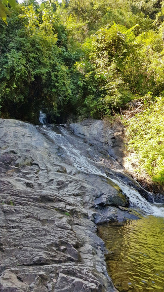
A great little hike with some absolutely amazing views, nature and to top it all off you have an excellent plunge pool waterfall, Khiri Phet Waterfall, to cool yourself down in when you are done.
Khiri Phet Waterfall


If you are experienced hikers in Thailand you will have no problem doing this. If you are not experienced in hiking in Thailand and jungles, then get a guide. Below are a few more pictures of the raw beautiful nature along the hike.
Special thanks to Ian at at Facebook: Iamkohchang and Website Iamkohchang. Ian has the most insightful website on Koh Chang I have found.


